Date Posted:10 September 2019
How can I determine if my property is in a high bushfire risk area, in preparation for this summer?
The Victorian Bushfires Royal Commission looked at the circumstances in which 173 people died on Black Saturday.
It concluded, that while most people understood they were at risk, 24 per cent weren’t even aware that they were in danger of bushfires!
With severe droughts and pre-season bushfires, coupled with an early fire season being announced this year, it is increasingly important that we all are made aware of the precautions to take if we live or work in a high risk bushfire area.
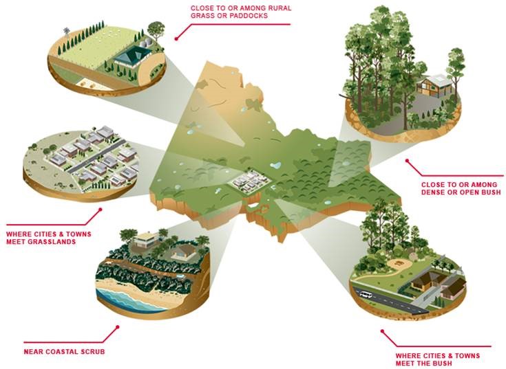
Two main factors to consider, when evaluating your property’s level of bushfire risk, are 1. how close it is to a ‘forest’ - Did you know, the definition of a forest is bushland covering more than 0.2 hectares? — that's about the size of four house blocks. 2. if your property is on a slope, as fire travels faster uphill. Hills and roads with multiple bends also lead to unsafe conditions whilst panicking escapees in vehicles are attempting to drive to safety, in congested, smoke-clouded traffic.
Andrew Gissing, general manager of resilience at Risk Frontiers (private research company modelling natural hazard risks) said anyone living with 500 metres of the bush should be aware of the risk and how to prepare for it, though properties have been lost further than 500 metres from bush land.
According to abc.net.au there is no national publicly available database that determines if you are at risk of bushfire, however the New South Wales and West Australian fire services have websites where you can enter your address to determine if it is in a fire-prone area, and South Australia has a map showing Bushfire Safer Places.
The Country Fire Authority in Victoria provides online diagrams to help people identify their property's risk.
Many of the locations with the largest proportion of high-risk addresses are thinly populated rural areas, but four are in heavily populated areas of our capital cities. These are Hornsby and Ku-Ring-gai in Sydney, Logan in Brisbane and The Adelaide Hills.
The chart below identifies the top 25 local government areas with a large proportion of high bushfire risk addresses.
| TOP 25 LOCAL GOVERNMENT AREAS WITH A LARGE PROPORTION OF HIGH-RISK ADDRESSES | |||
| Local Government Area | State | % of Addresses at High Risk | Total Population |
| Tasman | TAS | 61.7 | 2,372 |
| Blue Mountains | NSW | 51.7 | 76,902 |
| Huon Valley | TAS | 40.1 | 16,199 |
| Eurobodalla | NSW | 40.1 | 37,229 |
| Mundaring | WA | 38.1 | 38,159 |
| Scenic Rim | QLD | 35.3 | 40,078 |
| Chittering | WA | 30.9 | 5,474 |
| Murrindindi | VIC | 30.0 | 13,730 |
| Hornsby | NSW | 29.8 | 142,666 |
| Ku-ring-gai | NSW | 29.7 | 118,053 |
| Kingborough | TAS | 28.9 | 35,852 |
| Hawkesbury | NSW | 28.6 | 64,591 |
| Derwent Valley | TAS | 27.7 | 10,022 |
| Toodyay | WA | 27.6 | 4,442 |
| Murchison | WA | 27.3 | 153 |
| Wollondilly | NSW | 25.3 | 48,520 |
| Bega Valley | NSW | 25.3 | 33,254 |
| Adelaide Hills | SA | 25.2 | 38,864 |
| Ipswich | QLD | 25.0 | 193,737 |
| Port Stephens | NSW | 23.5 | 69,556 |
| Doomadgee | QLD | 23.3 | 1,398 |
| Shoalhaven | NSW | 22.1 | 99,649 |
| Logan | QLD | 22.0 | 303,384 |
| Central Coast | NSW | 21.7 | 2,1362 |
| Sunshine Coast | QLD | 20.8 | 294,365 |
| Total | 1,710,011 | ||
If you are living in a fire risk area, it is best to have protection. Thermaguard® is a one of the leading manufacturers of Personal Protective Blankets in Australia. Our Bushfire blankets are designed to exceed the specification for personal protective fire blankets set by the Australian Fire and Emergency Service Authorities Council (AFAC). You may also check our our Extrication Blankets, which were independently tested to exceed the AS4824:2006 Wildland Firefighters’ Clothing Standard by up to 200%.